|
|
 ABOUT CAPPADOCIA
 |
|
|
|
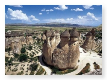
During
the WarthÆs formation,in the Third Geological
Period,when great changes were in affect a chain
of discounted volcanic activities was created
within Central Anatolia. The Erciyes Mountain (
Argeus 3916 m ),The Mount Hasan ( Athar 3256 m
) and Melendiz Mountain ( 2935 m ) erupted after
each other.In the North, the laves of Melendiz
and Hasan Mountains mixed with that of Erciyes
and formed a small plateau.Both volcanic
mountainsÆrepaetedly continued activities forced
the Central Anatolia to be formed under the
seccession of lavas,tufe and volcanic ashes and
dusts.
The
orhographic state of the area is only seen in
Cappadocia. In such an area like Cappadocia
there are rivers with plenty and continuosly
flowing waters. K²z²l²rmak ( The Red River )
which divides
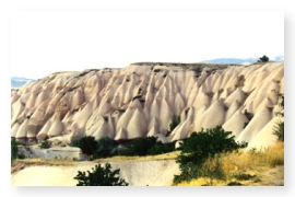 Cappadocia
into two parts is one of them.It receives water
foram many sources and serves important duties
in descharging the snow melted waters. Cappadocia
into two parts is one of them.It receives water
foram many sources and serves important duties
in descharging the snow melted waters.
There are also a number of craters lakes and
some natural springs. (up to 60 C hot ) in the
area.In winter,it snows heavily for three to
four months.In the high plateau the nights
become cold.There are sudden changes of seasons.the
erosion which is caused by these weather
conditions made special shapes of rock splits,
lave and tufa over the different hardness and
texture of the land.( Fairy Chimneys, for
instance )
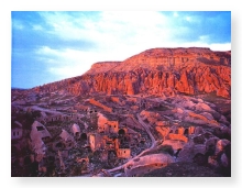 All
of these strange formations and easily carved
rocks were and stil are used as houses by the
local people for centruries.They are resembled
like a mole nest by making stores,temples,shelters,graves
and pigeon lofts. All
of these strange formations and easily carved
rocks were and stil are used as houses by the
local people for centruries.They are resembled
like a mole nest by making stores,temples,shelters,graves
and pigeon lofts.
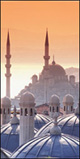
About Turkey
- About
Istanbul -
About Cappadocia
- About
Ephesus |
|
|
|